Enhance Your Photography with GPS Map Live Earth Camera
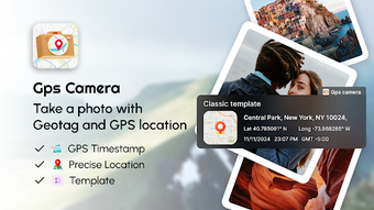
GPS Map Live Earth Camera is a free Android application that combines photography with precise geolocation features. Designed for travelers, photographers, and professionals, this app allows users to geotag their images with GPS coordinates, altitude, and compass direction, ensuring that every photo is enriched with accurate location data. With its user-friendly interface, the app makes it easy to document and remember where each picture was taken, making it an invaluable tool for anyone who captures moments around the world.
The app's integration with live Earth maps provides a high-resolution view of your surroundings, allowing you to switch between different map types, including satellite and terrain views. Additionally, the Street View mode lets users explore areas in 360 degrees before or after taking photos, adding depth to their photographic experience. Users can also customize timestamps on their images, ensuring that every photo carries a clear record of its date and time, tailored to individual preferences.